وادي الحسا
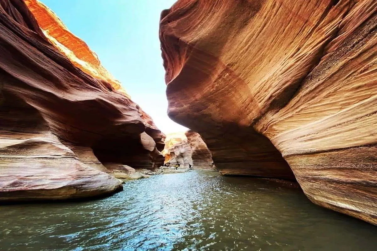
Wadi Al-Hasa is one of Jordan’s most remarkable natural valleys, offering a unique blend of environmental and historical significance. Stretching about 40 kilometers between Karak and Tafileh and flowing into the Dead Sea, it is among the longest valleys in the country. Unlike many desert wadis, Al-Hasa has permanent water sources fed by natural springs, supporting agriculture and local communities. Historically known as Wadi Zared in ancient texts, it served as a geographic boundary in the Levant. The valley’s geology limestone, sandstone, and basalt formations, provides a rich record for researchers studying climate and earth history. Today, Wadi Al-Hasa is a popular eco-tourism destination for hikers and adventurers, admired for its scenic landscapes, flowing streams, and biodiversity. The construction of Al-Tannur Dam in 1999 further enhanced its role as a vital water resource in one of the world’s most water-scarce countries.
About the Landmark
Trails & Valleys
Wadi Al-Hasa is one of Jordan’s most remarkable natural valleys, offering a unique blend of environmental and historical significance. Stretching about 40 kilometers between Karak and Tafileh and flowing into the Dead Sea, it is among the longest valleys in the country. Unlike many desert wadis, Al-Hasa has permanent water sources fed by natural springs, supporting agriculture and local communities. Historically known as Wadi Zared in ancient texts, it served as a geographic boundary in the Levant. The valley’s geology limestone, sandstone, and basalt formations, provides a rich record for researchers studying climate and earth history. Today, Wadi Al-Hasa is a popular eco-tourism destination for hikers and adventurers, admired for its scenic landscapes, flowing streams, and biodiversity. The construction of Al-Tannur Dam in 1999 further enhanced its role as a vital water resource in one of the world’s most water-scarce countries.
Wadi Al-Hasa is one of the most prominent natural valleys in Jordan, a geographical and tourist landmark that combines environmental and historical significance, making it a unique example of the interaction between nature and civilization through time. Located in the western part of southern Jordan, between the governorates of Karak and Tafila,emptying into the southern Dead Sea at the Al-Safi area, becoming an important part of its water basin.
Wadi Al-Hasa extends for approximately 40 kilometers, making it one of the longest and widest valleys in Jordan, even surpassing Wadi Al-Mujib to its north. The valley is characterized by its diverse topography, which includes steep rocky slopes, agricultural areas, narrow plains, and numerous watercourses.
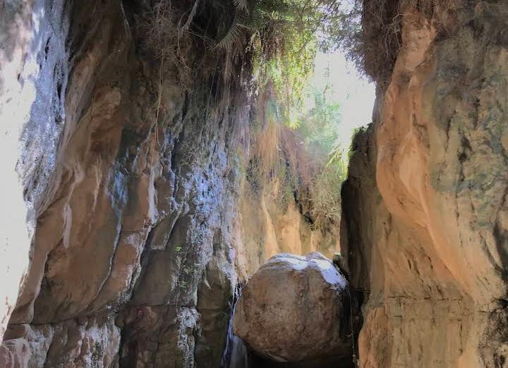
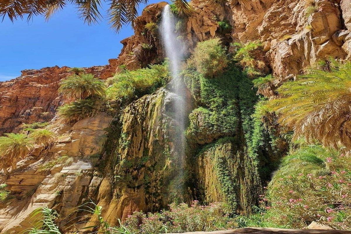
One of the most distinctive features of Wadi Al-Hasa is its year-round water supply, a rarity in many desert valleys. This is due to the presence of several natural springs and wells that feed it, particularly in the section belonging to the Tafila Governorate. This water is used for agriculture and provides water for the local population, giving the valley economic importance in addition to its natural value.
The valley is part of the hydrological system associated with the Dead Sea, with a water basin covering approximately 2,500 square kilometers, making it one of the most important water basins in Jordan.
Historically, Wadi al-Hasa is known as Wadi Zered, a name found in ancient texts, particularly Hebrew writings. This name reflects the valley’s antiquity and historical significance, as it formed an important geographical boundary in ancient times and may have served as a natural passage or route between different regions.
The fact that it has multiple names across languages (Arabic, English, and others) also indicates its place in the historical geography of the region, as it is mentioned in various sources as one of the well-known natural landmarks of the Levant.
The valley is considered a rich environment in terms of natural diversity, as it has water and relatively fertile soil compared to the surrounding desert areas. Therefore, many farms are located along its sides, especially in areas near the watercourse, where various vegetables and crops are cultivated.
The valley also contains diverse natural vegetation and is home to several organisms that depend on the presence of water and vegetation. This environment plays an important role in maintaining the ecological balance of the region, especially given the arid nature that prevails in most parts of Jordan.
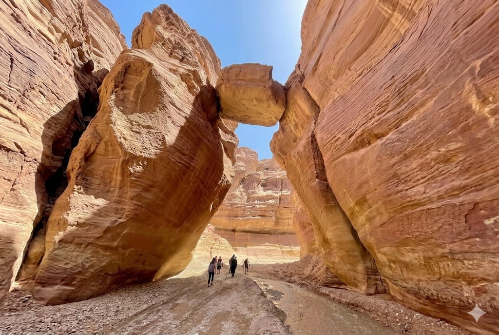
Wadi Al-Hasa is a favorite destination for nature and adventure enthusiasts in Jordan. Because ofits stunning scenery, flowing water, and diverse terrain, it has become a popular spot for hikers, walkers, and explorers.
It trail stretches for approximately 30 kilometers, making it suitable for adventure trips lasting a full day or more. The presence of a permanent water source provides a unique experience for visitors, especially during the summer months, when the valley offers respite from the intense heat.
Furthermore, the valley boasts natural beauty, combining colorful rocks, flowing water, and lush greenery, making it a prime location for photography and ecotourism.
One of the most prominent projects associated with Wadi Al-Hasa is the Tannour Dam, constructed in 1999. It is considered one of Jordan’s most important water projects. With a storage capacity of approximately 16 million cubic meters of water, it aims to store floodwater for agricultural use and water conservation.
This project has contributed to enhancing the utilization of the valley’s water resources, especially given the water scarcity in Jordan, which is considered one of the world’s poorest countries in terms of water resources.
Wadi Al-Hasa is an important part of the local identity, who depend on it for agriculture and grazing, and it is deeply intertwined with their daily lives. Several historical and ancient structures are scattered throughout the area, reflecting human settlement in the valley for centuries.
The valley also stands as a testament to the relationship between humans and nature in the Jordanian environment, demonstrating how the inhabitants have adapted to challenging conditions and utilized available resources sustainably.
That’s explain why it is one of the most important valleys in Jordan, boasting unique natural features and significant historical and economic importance. It is not merely a waterway, but a complete ecosystem and an important resource for the local population, in addition to being a distinctive tourist destination.
It portrays the diversity of nature in Jordan, where mountains, deserts, and water converge in a single landscape, making it a prime example of the beauty and significance of the Jordanian environment. With the growing interest in ecotourism and the preservation of natural resources, Wadi Al-Hasa remains a site deserving of further study, protection, and sustainable investment.
To its geological characteristics:
Wadi Al-Hasa is distinguished by geological formations dating back to different eras, with its rocks composed of limestone, sandstone, and basalt in some areas. These formations resulted from long-term natural processes such as erosion and deposition, leading to the formation of the steep slopes and deep gorges that characterize the valley today.
The rock layers in the valley reveal a rich geological record that helps researchers study the history of the region, particularly in terms of climate change and tectonic plate movement. The presence of certain minerals in its soil also indicates potential economic opportunities, although their exploitation remains limited.
Landmark Photos
Click any image to update the main preview, or open it full size.
وادي الحسا
Click image to enlarge
Location on Google Maps
Related Places
Wadi Al-Numayra
A breathtaking 'Rose Siq' in Karak where fresh springs meet vibrant sandstone walls. An ideal destination for adventure seekers and a perfect digital detox in the heart of Jordan’s raw nature
Wadi Wyda’a
A hidden healing oasis in the heart of Karak, where mineral springs burst from pristine cliffs. The ultimate destination for those seeking adventure and serenity in an authentic, untouched natural landscape.
Wadi Al-Karak
Nearby Restaurants
3


Add this landmark to your trip plan
Use the smart trip planner to design the perfect Karak tour